GIS Geographical Information Systems

lat. 21°
24'58.21"N long. 157°
44;58.33'W
Antmet
qgis_logo.png


The deFacto Standard in GIS

WCC

Professor Floyd McCoy

Professor David Krupp

Professor Toshi Ikigawa


 TMK Map by HoLIS

State of Hawaii Layers
State of Hawaii GIS Program
gis_book
Fall 2008 Class at WCC
Geographical Information Systems 150

Spring 2009 Class at WCC
Natual Resources and Envriomental Management 250
Ocean Book
Fall 2009 class at WCC
Oceanography 201
Ocean Book

Fall 2010 class at WCC Geology 103

Keaahala stream

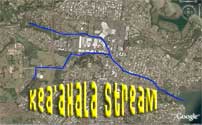
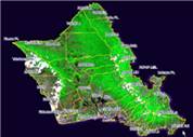
Stream Mapping Project OCN-199