
| ArcGIS Field | Oahu_Street_n83 |
| House From Left | SCLL |
| House To Left | SCLH |
| House From Right | SCRL |
| House To Right | SCRH |
| Prefix Direction | PREDIR |
| Prefix Type | <None> |
| Street Name | NAME |
| Street Type | TYPE |
| Suffix Direction | <None> |
| Left Zone | ZIPCODEL |
| Right Zone | ZIPCODER |

| OID | N1 | N2 | N3 | N4 | N5 | N6 |
| Unique Number | NFIRS tracking number | Type of Incident | Address | NSEW | Street Name | Street suffix |
| First Column | Second Column | Third Column | Fourth Column | Fifth Column |
| Number Address | Street | City | State | Zip Code |
 Arc
Catalog http://webhelp.esri.com/arcgisdesktop/9.3/index.cfm?TopicName=Creating_an_address_locator
Arc
Catalog http://webhelp.esri.com/arcgisdesktop/9.3/index.cfm?TopicName=Creating_an_address_locator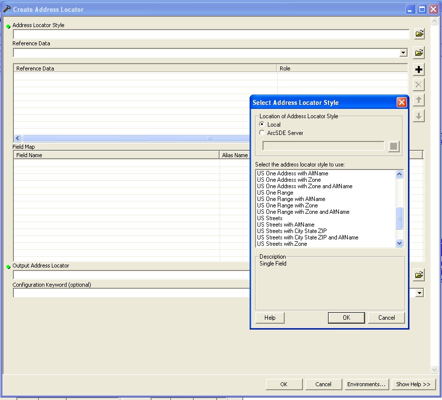
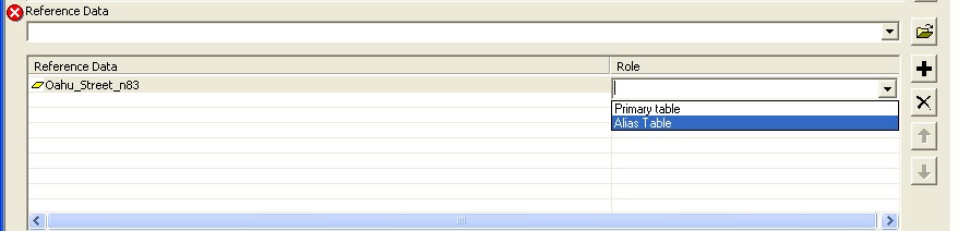
This was difficult at first becasue after you identify where the Reference Data is you still have the red circle with the X. What you need to do is click the cloumn under Role and then go down and choose Primary Table. After that the red circle with the X will disapear.

Field Map can not be overlooked and must be dealt with (at least the ones with astericks) If there is a problem building the Address Locator try and give Output Address Locator a explict address by clicking on the folder icon and navigating to the folder you want it saved in.
| File Name: Oahu_Street_n83 | |
| OBJECTID_1,N,9,0 | Unique object identification |
| LPOLY_,N,9,0 | Zero only |
| RPOLY_,N,9,0 | Zero only |
| LENGTH,N,19,11 | |
SEGMENTID,N,19,11 |
|
FULLNAME,C,50 |
Full Name with type of Street |
| PROPERNAME,C,50 | All Blank |
| PREDIR,C,2 | E-423 N-452 S-227 W-365 Total 1,467 |
| TYPE,C,4 | see breakdown to the right |
| POSTDIR,C,2 | Blank or East West 5303 |
| SCLL,N,19,11 | |
| SCLH,N,19,11 | |
| SCRL,N,19,11 | |
| SCRH,N,19,11 | |
| ZIPCODEL,C,5 | |
| ZIPCODER,C,5 | |
| NAME,C,40 | |
| TYPE | Count |
| AVE | 1533 |
| BLVD | 200 |
| CIR | 102 |
| CRSE | 1 |
| CT | 11 |
| DR | 1117 |
| EXIT | 206 |
| EXT | 206 |
| FWY | 494 |
| LN | 214 |
| PKWY | 49 |
| PL | 2801 |
| RAMP | 271 |
| RD | 1863 |
| RISE | 18 |
| ROW | 1 |
| SQ | 1 |
| ST | 9443 |
| TER | 2 |
| TRL | 4 |
| WALK | 7 |
| WAY | 322 |
| Total | 25,323 |
| File Name: tigroads02_n83 | |
| OBJECTID,N,9,0 | Unique object identification |
| TLID,N,19,11 | lots of values |
| FEDIRP,C,2 | E-266 N-398 S-434 W-290 Total(0)- 84,081 |
| FENAME,C,30 | Name values |
| FETYPE,C,4 | |
| FEDIRS,C,2 | |
| CFCC,C,3 | |
| FRADDL,C,11 | many values, some with hyphens |
| TOADDL,C,11 | many values, some with hyphens |
| FRADDR,C,11 | many values, some with hyphens |
| TOADDR,C,11 | many values, some with hyphens |
| ZIPL,N,9,0 | contains various Oahu zip codes |
| ZIPR,N,9,0 | contains various Oahu zip codes |
| FULLNAME,C,50 | Full Name (with Street type) |
| ISLELEFT,C,2 | see left in below chart |
| ISLERIGHT,C,2 | see right in below chart |
| Shape_Leng,N,19,11 | self explanatory |
| FETYPE | |
| Type | Count |
| 0 | 35,473 |
| Ave | 3,581 |
| Blvd | 581 |
| Brg | 6 |
| Byp | 27 |
| Cir | 386 |
| Ct | 196 |
| Dr | 3198 |
| Fwy | 9 |
| Grd | 17 |
| Hwy | 3,174 |
| Ln | 660 |
| Loop | 922 |
| Mal | 1 |
| Path | 33 |
| Pky | 335 |
| Pl | 5,606 |
| Rd | 12,597 |
| Row | 17 |
| Sq | 2 |
| St | 17,492 |
| Ter | 6 |
| Thfr | 1 |
| Tr | 305 |
| Walk | 6 |
| Way | 568 |
| Total | 49.726 |
| CFCC | Count |
| A11 | 305 |
| A14 | 2 |
| A15 | 23 |
| A21 | 4,124 |
| A25 | 4 |
| A31 | 2,247 |
| A35 | 7 |
| A38 | 1 |
| A41 | 68,978 |
| A42 | 2 |
| A43 | 1 |
| A45 | 1 |
| A47 | 27 |
| A51 | 3,932 |
| A52 | 1 |
| A63 | 277 |
| A64 | 8 |
| A70 | 3 |
| A72 | 1 |
| A73 | 1 |
| A74 | 5,061 |
| P41 | 185 |
| P51 | 9 |
| P74 | 1 |
| Right | Count | Left | Count |
| HA | 30,971 | HA | 30.971 |
| KA | 11,986 | KA | 11,986 |
| LA | 1,102 | LA | 1,102 |
| MA | 11,584 | MA | 11,584 |
| MO | 2,957 | MO | 2,957 |
| NI | 5 | NI | 5 |
| OA | 26,864 | OA | 26,864 |