Module 4 Project 1
Q1) What geographic
area are you studying?
Gulf of Mexico. Specifically southern Mississippi (Hancock County, Harrison County, and Jackson County).
Q2) What decision do you need to make?
Where best to allocate their disaster aid for the three counties in Mississippi.
Q3) What information would help you make the decision?
Pre-flood data of geographical features. Data that can demonstrate what geographical areas the flood changed, this would also help established what has not changed. Census data would also help identify what areas relief should be directed to.
Q4) Who are the key stakeholders for this issue? (This step is important. You need to know the audience for your analysis to help decide how to present your results.)
The greatest bureaucracy ever known to the world the “United States Government.” The main economic aide would come from the Federal Government, while state and local governments would need this type of data to plan rebuilding damaged areas.
Q5) Investigate the metadata and complete this table:
| Layer | Data Type | Publication Information: Who Created the Data? | Time Period Data is Relevant | Spatial Horizontal Coordinate System | Attribut Values | Resolution for Rasters |
| airports | Vector | US Geological
Survey Reston, VA Tele Atlas North America, Inc., ESRI |
2006 | GCS_WGS 1984 | N/A | N/A |
| curches | Point | Tele Atlas North America, Inc., ESRI | 2006 | GCS_North_American_1983 | Census data | N/A |
| counties | Vector | US Geological Survey Reston, VA | GCS_North_American_1983 | County | N/A | |
| elev |
Rastar | US Geological Survey Reston, VA | 1999 | GCS_North_American_1983 | Elevation is expressed in meters | 1 arc second 0.000278 decimal degrees 30 meters |
| hospitals | Vector | Tele Atlas North America, Inc., ESRI | 2006 | GCS_North_American_1983 | Street Data |
N/A |
| landcover | Rastar | US Geological Survey Souix Falls, SD | 2001 | NAD_1983_Albers | N/A | 1 arc second 0.000369 30 meters |
Q7) What are the names of the counties in order from west to east?
Hancock County, Harrison County, and Jackson County.
Q8) What does this map show you about the Gulf Coast?

Q9) Describe the spatial distribution of features.
See Map above.
Q10) How might these be affected by a large storm surge?
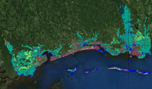
Most all maps reveal the major vulnerability of this geographic area which is the low lying areas that make up the south coast states. When viewing the map that shows Interstate 10, it becomes clear that it acts as a rough demarcation line.
Q12) Record the sum, which represents the number of pixels that were flooded.
1,383,223.
Q13) What does the graph tell you about the greatest impact of the storm surge? Everything south of Interstate 10 will be in great need of relief and various services. We can also see that Interstate 10 will be very important way to bring in relief and take residents out.
Q14) Describe the distribution of the flooded areas and how the flood might affect the long-term sustainability of the region.
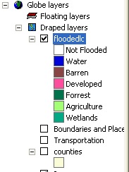
It seems evident to some one like myself who does not have an economic stake in the region that for long term sustainability development must be curtailed in the lowland and flood prone areas. The floodedlc layer provided very specific areas of damage.
As you can clearly see above (even thought this map is small) that all the Hospitals are located in areas that were severely flooded. This should reinforce the idea that Hospitals need to have strict building codes so they may endure severe catastrophic damage in hurricanes and still be able to deliver medical services.
 Jackson county Hospitals
 Gulfport-Billoxi Regional Airport
 Stennis International Airport
 Trent Lott International Airport
Q17) If you add a field called ACRES and use the Field Calculator, write the formula that you would use to calculate acres.
ACRES = COUNT*900/4046.68
(I'm not sure I understand the question, this is the formula the book gave and I used)
Q18) If you add a field called SQMILES, write the formula that you would use to calculate square miles.
SQMILES = ACRES/640
(I'm not sure I understand the question, this is the formula the book gave and I used)
| Type of Land | Acres | Square Miles |
| Developed | 11,541 | 18.0328 |
| Not Flooded | 103,016 | 160.9625 |
| Barren | 176,009 | 275.0147 |
| Agriculture | 386,444 | 603.8193 |
| Wetlands | 509,072 | 795.4264 |
| Forest | 514,379 | 803.7186 |
| Water | 554,574 | 866.5231 |
Stennis International AirportTrent Lott International AirportQ17) If you add a field called ACRES and use the Field Calculator, write the formula that you would use to calculate acres.
ACRES = COUNT*900/4046.68
(I'm not sure I understand the question, this is the formula the book gave and I used)
Q18) If you add a field called SQMILES, write the formula that you would use to calculate square miles.
SQMILES = ACRES/640
(I'm not sure I understand the question, this is the formula the book gave and I used)
| Type of Land | Acres | Square Miles |
| Developed | 11,541 | 18.0328 |
| Not Flooded | 103,016 | 160.9625 |
| Barren | 176,009 | 275.0147 |
| Agriculture | 386,444 | 603.8193 |
| Wetlands | 509,072 | 795.4264 |
| Forest | 514,379 | 803.7186 |
| Water | 554,574 | 866.5231 |

Back to Directory